Minnesota dam failure prompts Flash Flood Warning after deadly flooding forces residents from homes in Midwest
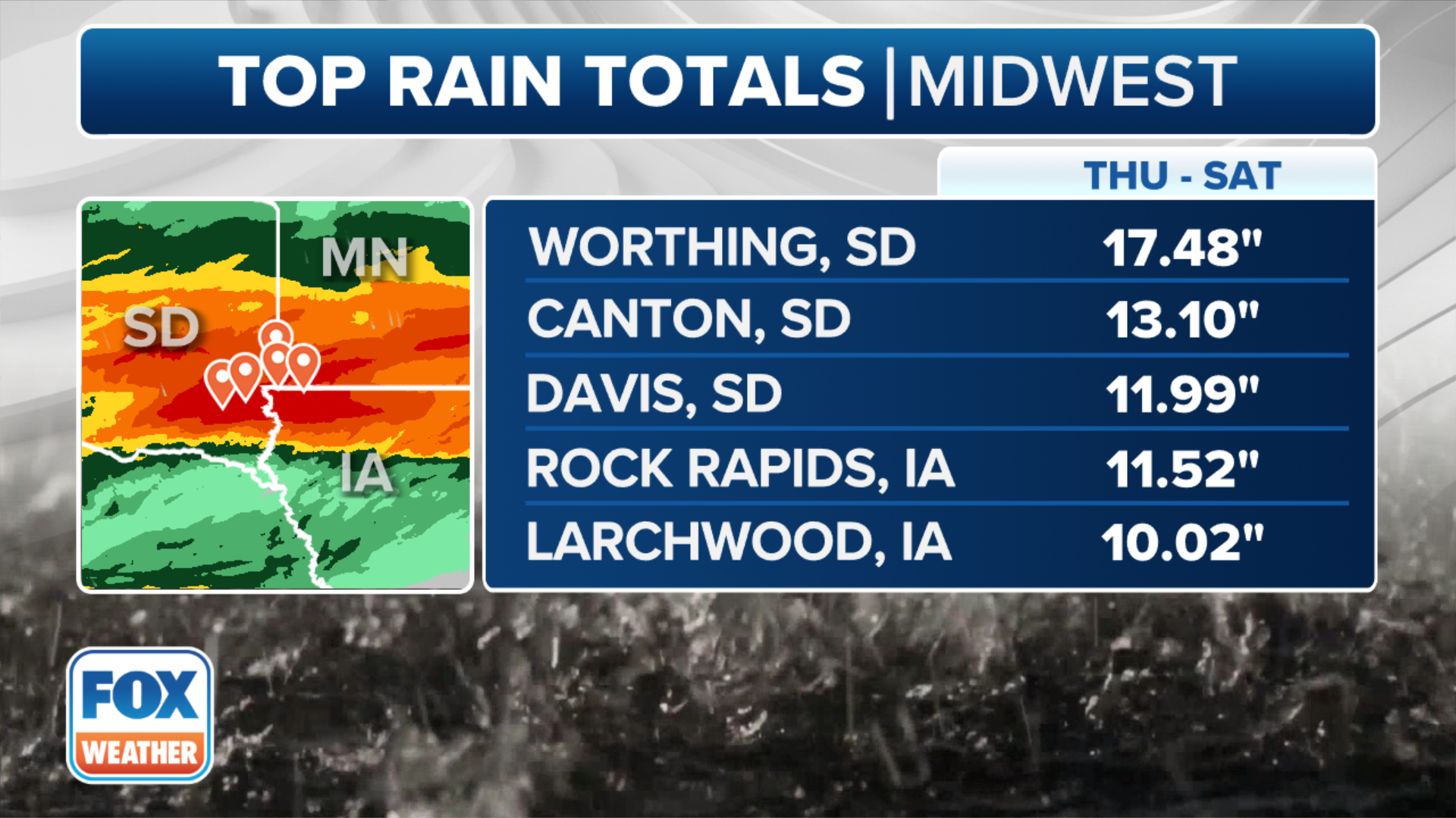
Rain gauges and radar estimates showed many areas picked up 8-18 inches of rain in parts of South Dakota, Iowa and Minnesota, and the ground didn’t have enough time to absorb all the water. That led to rapidly rising rivers and streams.
Flash Flood Warning ongoing for parts of Minnesota after unprecedented flooding
FOX News Multimedia Reporter Olivianna Calmes reports from North Sioux City, South Dakota where deadly flooding has destroyed homes and infrastructure.
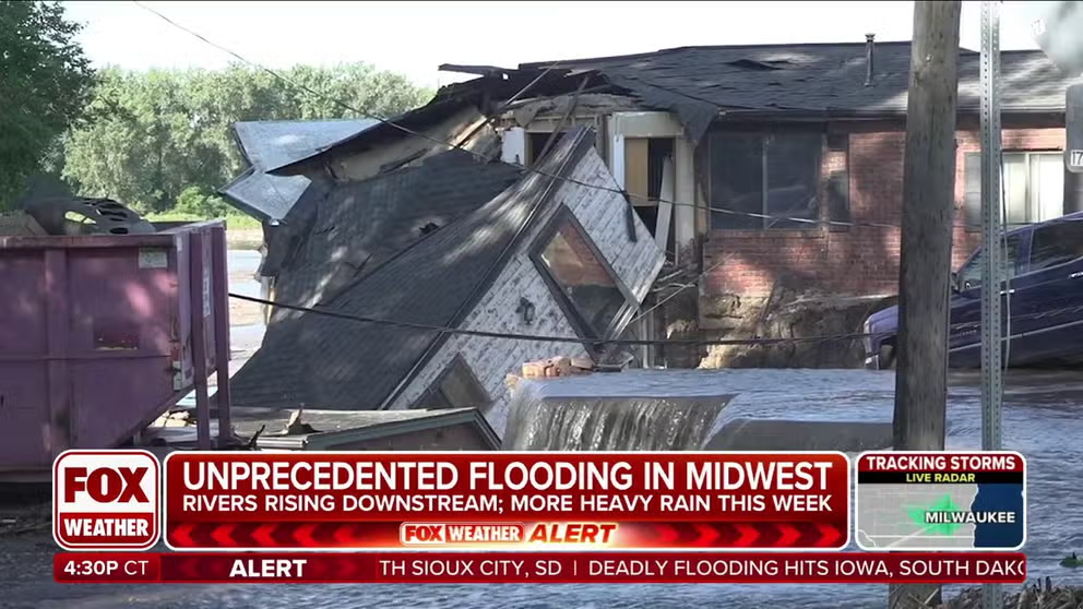
DES MOINES, Iowa – Relentless rounds of torrential rain and thunderstorms in the Upper Midwest and northern Plains over the weekend has led to catastrophic flooding that has so far claimed the life of at least one person and forced residents from their homes to escape rising water as rivers continue to overflow their banks.
The record-breaking flooding occurred as an area of low pressure slowly drifted over the region and dumped several inches of rain, with some areas receiving nearly 18 inches.
(FOX Weather)
Because the ground had been so saturated, it didn’t have enough time to absorb the water, which is what caused the flash flooding and river flooding that inundated numerous communities along rivers and streams in parts of South Dakota, Iowa and Minnesota.
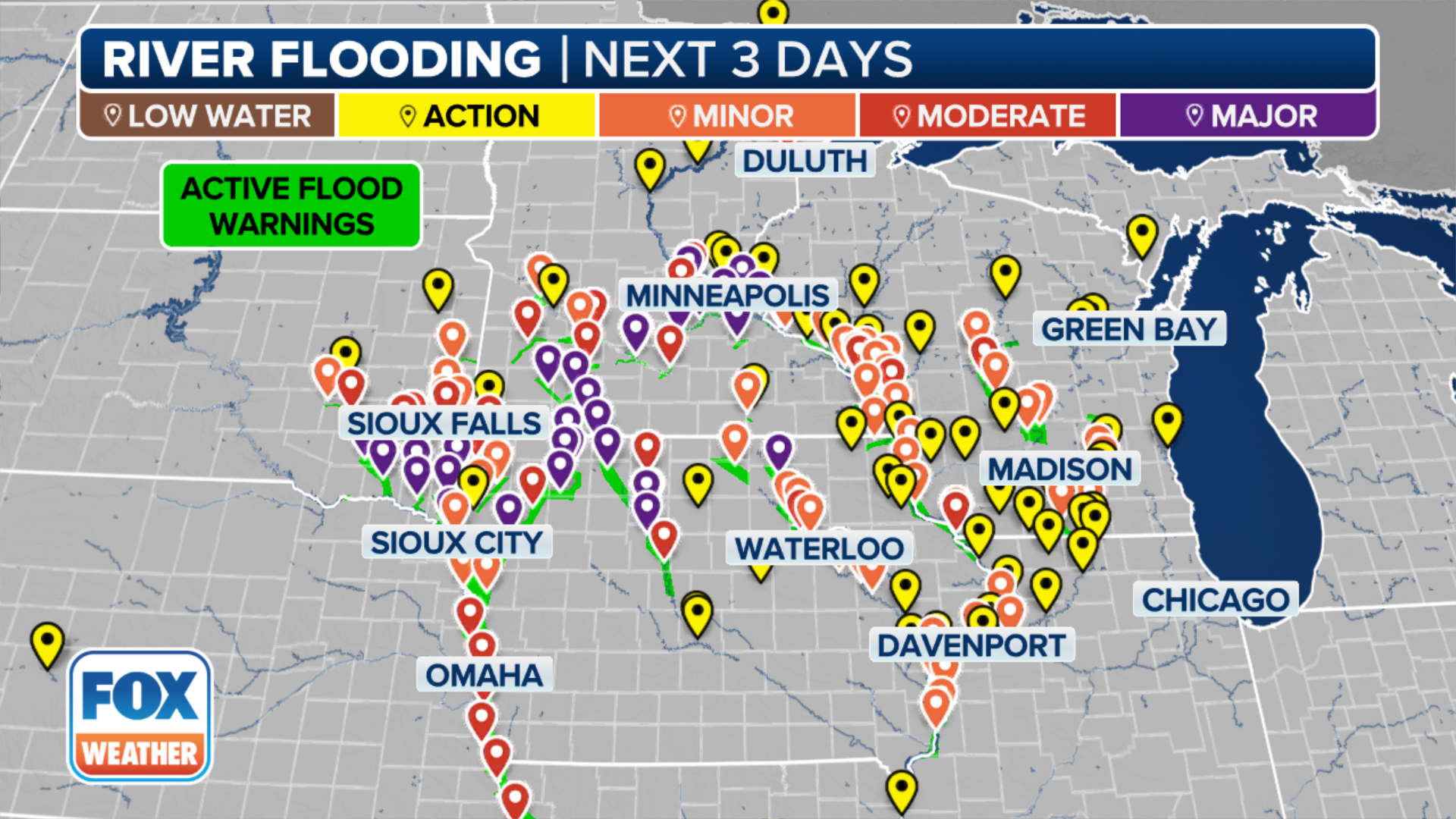
Dozens of rivers have, or will, reach moderate or major flood stage, and Flood Warnings remain in effect until further notice.
Minnesota dam failure prompts Flash Flood Warning
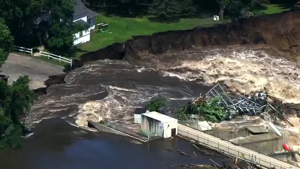
Watch: Minnesota dam in danger of failing due to catastrophic flooding
Video recorded above the Rapidan Dam in Minnesota shows the structure in danger of failing due to flooding caused by days of torrential rain in the Midwest. Residents downstream have been warned about the situation.
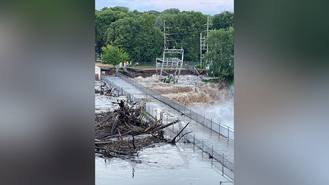
Residents living downstream from the Rapidan Dam in Blue Earth County, Minnesota, have been notified of its imminent failure due to accumulating debris that has compromised the structure.
"We do not know if it will totally fail, or if it will remain in place," the Blue Earth County Sheriff’s Office said in a Facebook post. "However, we determined it was necessary to issue this notification to advise downstream residents and correct regulatory agencies and other local agencies."
This photo shows the Rapidan Dam in danger of failing after flooding in Minnesota.
(XcelEnergyMN/X)
The sheriff’s office said steps in the Rapidan Dam Emergency Action Plan for Imminent Failure of the Dam are being implemented, including the notification of potentially affected residents, impacted regulatory agencies and other local agencies.
On Monday afternoon, the sheriff's office said there was a partial failure on the west abutment and there are no current plans for a mass evacuation.
Officials said the Blue Earth River has significantly cut around the west side of the dam, and Xcel Energy and county infrastructure have added to the debris in the river.
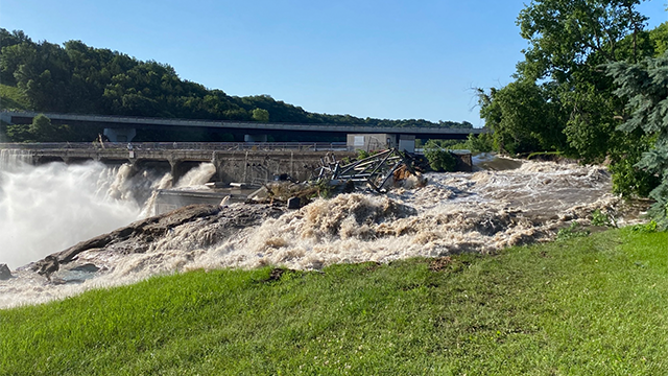
This photo shows a substation that was washed away by flooding at the Rapidan Dam in Minnesota.
(XcelEnergyMN/X)
"We are aware of power outages and are working with Xcel Energy," the sheriff’s office said. "The County Road 33 bridge and County Road 90 bridge are being closely monitored for debris passing downstream and may be closed if needed."
Because of the potentially dangerous situation unfolding, a Flash Flood Warning was issued for the area.
"At 10:34 a.m. CDT, dam operators reported the river has eroded earth around the dam and is uncontrolled," the National Weather Service said. "This may result in flash flooding downstream along the Blue Earth River."
Rainfall rates between 1 and 2 inches are forecast for Monday evening in east-central Minnesota.
The National Weather Service Twin Cities warns that because of recent rainfall and flooding, any additional rain could lead to flash flooding.
1 dead, railroad bridge collapses in South Dakota
South Dakota has been hard hit by the flooding, and at least one person has been killed in the state.
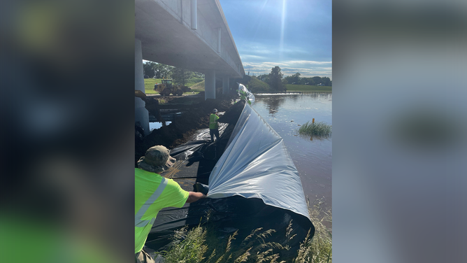
In addition, the South Dakota Department of Transportation spent time on Sunday building a berm across both lanes of Interstate 29, which has been closed in an attempt to protect North Sioux City and the Dakota Dunes from the flooding.
Parts of Midwest see worst flooding on record after days of torrential rain
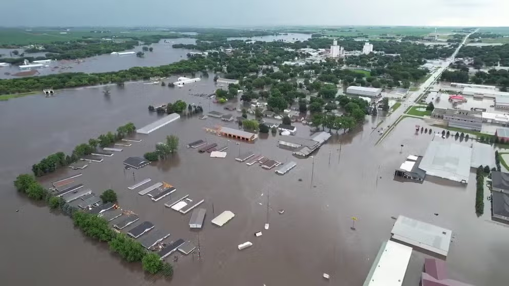
Historic and deadly flooding has impacted numerous communities across the Upper Midwest after days of relentless rain caused rivers and streams to overflow their banks and send water rushing into cities in South Dakota, Iowa and Minnesota.
"The protective structure will connect with an existing levee on the east side of North Sioux City," SDDOT said in a post on X, formerly Twitter.
A detour has since been set up to help travelers get around the closure of I-29.
DOWNLOAD THE FREE FOX WEATHER APP
![A berm is built across I-29 in South Dakota on Sunday, June 24, 2024.]() Image 1 of 4
Image 1 of 4A berm is built across I-29 in South Dakota on Sunday, June 24, 2024. (SDDOT/X)
![A berm is built across I-29 in South Dakota on Sunday, June 24, 2024.]() Image 2 of 4
Image 2 of 4A berm is built across I-29 in South Dakota on Sunday, June 24, 2024. (SDDOT/X)
![A berm is built across I-29 in South Dakota on Sunday, June 24, 2024.]() Image 3 of 4
Image 3 of 4A berm is built across I-29 in South Dakota on Sunday, June 24, 2024. (SDDOT/X)
![A berm is built across I-29 in South Dakota on Sunday, June 24, 2024.]() Image 4 of 4
Image 4 of 4A berm is built across I-29 in South Dakota on Sunday, June 24, 2024. (SDDOT/X)


At a news conference on Sunday afternoon, South Dakota Gov. Kristi Noem said one person was killed in the flooding, but she didn’t provide any additional details.
"All I’m going to say is that I want to remind everybody to remember the power of water and the flow of water and to stay away from flooded areas," she said at the news conference.
According to a report from SiouxlandProud, a rail bridge between North Sioux City and Riverside partially collapsed because of the flooding late Sunday night. The report says the bridge was located above the Big Sioux River between North Sioux City and the Riverside neighborhood of Sioux City, Iowa.
NATIONAL WEATHER SERVICE REVAMPS FLOOD ALERTS
Levee break leads to Flash Flood Emergency in northern Iowa
Watch: Flooding leads to evacuations in Rock Valley, Iowa
Drone video captured by Carter Vanden Bos shows widespread flooding in the western area of Rock Valley City in Iowa on Saturday, June 22, 2024.
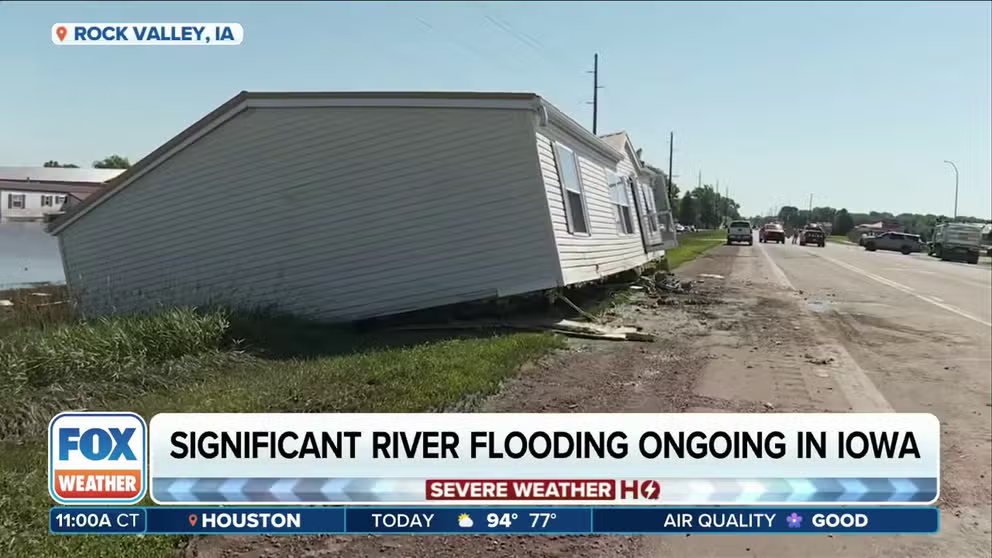
The already-swollen rivers and the heavy rain caused a levee to break along the Rock River in Rock Valley, Iowa, early Saturday morning, which led to urgent evacuations and a Flash Flood Emergency.
City officials even sounded tornado sirens to get the town’s attention to the urgent and dangerous situation that was unfolding.
"We are setting off sirens in (Rock Valley)," the Sioux County Sheriff’s Office posted on social media. "This means to evacuate your house if able."
Rock Valley city officials have been posting regular updates on social media for residents and said at least two bridges and roads had been washed away.
"Using pickups, tractors, trucks or loaders is no longer an option for evacuation because of the water current and height," officials said Saturday. "Please know all boats and teams are doing all they can to get each and every one of your loved ones."
Iowa Gov. Kim Richards issued an emergency disaster proclamation for Sioux County, directing state resources to help Rock Valley and other flooded communities in Iowa.
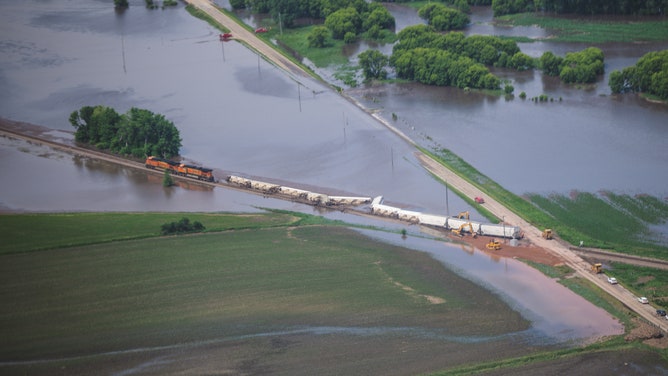
Nine cars of a train derailed in floodwater in Lyon County, Iowa on June 21, 2024.
(Warrior Sports Photography)
Several water rescues have also been conducted in Iowa’s O’Brien County, and a train derailed in Lyon County near Alvord.
Nine train cars were knocked off the tracks about 4:30 a.m. local time Friday, but no hazardous materials were spilled or involved.
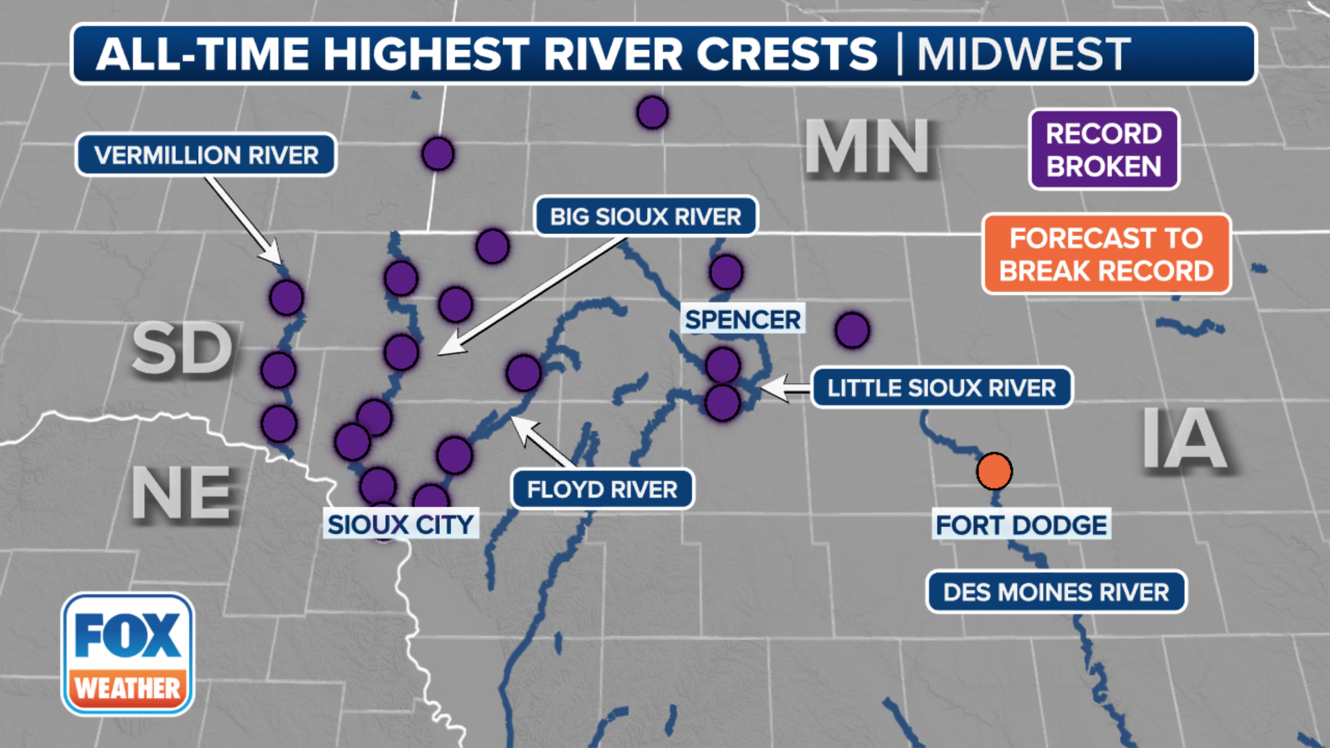
Record flooding reported on numerous rivers
(FOX Weather)
Multiple river gauges have exceeded their all-time highest crest, and many others are expected to be added to the list.
River basins in Iowa and southeastern South Dakota are seeing the worst of it as they sit downstream of the heaviest rain, with the Big Sioux, Little Sioux, Ocheyedan, and Des Moines rivers among those forecast to exceed their record flood stage or have already done so.
(FOX Weather)
Flooding along the Big Sioux River at Hawarden exceeded its record by 4 feet and caused mandatory evacuations in the town. City officials say power was turned off to parts of town that are underwater, and the water and sewer treatment plant shut down due to inundation. Officials initially told residents not to use the water, but in an update on Sunday afternoon, they said the water in Hawarden was safe to drink.
Other rivers over record flood stage included the Rock River and Floyd River in Iowa and the Vermilion River in South Dakota.